15 Hidden Scenic Spots in Japan That Locals Actually Recommend
15 Hidden Scenic Spots in Japan That Locals Actually Recommend
Tired of crowded observation decks and the same postcard views? This guide pulls together 15 lesser-known landscapes across Japan where the quiet still lingers, complete with best seasons, ideal timing, and practical access details.
You already know the famous spots. But packed observation decks and the same recycled photos only go so far. This guide gathers 15 landscapes across Japan where the stillness remains, covering the best seasons to visit, the time windows worth targeting, and how to actually get there.
A quick note on terminology: in Japanese travel culture, "anaba" refers to a quality spot that hasn't been widely discovered, while "hikyo" originally means a remote, almost untouched area. In practice, though, "hikyo" has shifted to describe destinations that feel special and uncommonly quiet rather than literally unexplored. This guide uses both concepts loosely, focusing on the strength of the scenery, the absence of overcrowding, and whether the place actually works as a real trip.
Some of these spots transform dramatically when conditions align. The tidal mirror at Chichibugahama, the sea of clouds at Takeda Castle Ruins, the dawn reflections at Tsutanuma -- each has a narrow window where the landscape shifts into something extraordinary. Details on how to hit those windows are woven throughout. Information draws on sources published between 2024 and 2026, but admission fees, operating hours, and access restrictions change frequently. Treat official announcements as your final reference before any trip.
How We Chose These Hidden Scenic Spots in Japan -- And What "Hidden" Actually Means
First, some framing. In the dictionary sense, "anaba" (hidden gem) emphasizes a quality place that few people know about, while "hikyo" (secluded area) emphasizes remoteness and isolation. They started as distinct ideas -- one centered on the place being good, the other on the place being hard to reach.
In today's travel context, that line has blurred considerably. As the Japan Travel Bureau Foundation has discussed, "hikyo" now often means a destination you can reach, but that resists becoming routine -- a place that still carries a sense of discovery. Akiyamago (Akiyama Village) fits the classic mold with its deep, pervasive quiet across an entire valley. But Cape Kamui (Kamui Misaki, Hokkaido) and Tsutanuma (Tsuta Marsh, Aomori) carry nationwide recognition yet still offer breathing room depending on the time of day or season. Rather than drawing a rigid boundary, this guide picks up the compelling landscapes that sit just beyond the well-trodden path.
Three criteria drove the selection. The first is straightforward: visual impact. Ocean, lake, gorge, cave, night skyline -- genre doesn't matter, but the place needs to leave an impression both in photos and in person. The second: the crowds haven't overwhelmed it, or even if it's well-known, there's a realistic way to find calm by shifting your timing. Restricting the list to completely unknown spots would make trip planning impractical, so places like Chichibugahama at pre-sunset, Shirogane Blue Pond at dawn, and the Nabekanmuriyama Observatory at night are included because they offer gaps in the crowd cycle. The third: you can realistically visit on a weekend or in a 2-to-3-night trip. Driving helps at many spots, but each one was checked for whether public transit, or a train-plus-taxi combination, makes the trip viable. Scenic wonders that can't be folded into an actual itinerary didn't make the cut.
With these criteria applied, the lineup looks different from the usual "best views in Japan" list. The emphasis here is less on name recognition and more on places where conditions push the scenery a level deeper. Think reflections where water becomes a mirror, sea-of-clouds mornings shaped by cold air and humidity, underground spaces that feel like another world entirely, and nightscapes where city light rises as a luminous surface. At Chichibugahama, when the tide is ebbing and the wind drops out, the water mirror assembles itself. At Takeda Castle Ruins, a cloud sea emerges only on certain autumn-to-early-winter mornings when radiative cooling and moisture align. The Metropolitan Area Outer Underground Discharge Channel isn't a scenic landmark at all, yet its 59 columns standing roughly 18 meters tall create an otherworldly atmosphere that rivals any natural vista.
These "condition-dependent landscapes" are tough to reproduce just by showing up. That's why each entry below covers not just the best season, but what time of day to aim for, which transport option is realistic, and how much walking is involved. Major travel media in Japan have settled on a similar format -- bundling best season, time window, photo conditions, and access into a single package -- because a place's beauty alone doesn't guarantee you'll actually see it at its best. The same philosophy runs through this guide: practical usability within a real itinerary matters more than surface-level appeal.
One formatting note: Japanese place names that are difficult to read (even for native speakers) include phonetic guides in their first appearance -- for example, Kamui Misaki, Tsutanuma, Akiyamago, Shikaribetsu-ko (Lake Shikaribetsu), and Kottoi Station. Knowing the pronunciation makes transit searches and local information much easier to navigate.
On sourcing: the information here cross-references tourism boards, municipal sites, official facility pages, and specialized travel media published between 2024 and 2026. Scenic spots are a fast-moving category, though. Kiyotsu Gorge Tunnel adjusts its admission fee by season. Tsutanuma introduces a reservation system for its observation deck during peak autumn foliage. Cape Kamui changes gate operations based on weather. Rather than memorizing fixed details, treat fees, hours, passability, and access restrictions as information to verify right before your visit.
One more thing: in natural scenic areas, "quiet" does not mean "anything goes." Japan's Ministry of the Environment guidelines for national parks are clear -- stay on marked trails, respect conservation rules, and follow posted restrictions. Especially around marshes, wetlands, gorges, and cliffs, stepping off the path for a single photo can damage the landscape and compromise safety. The word "hidden gem" has an appealing ring, but these aren't places that belong to whoever finds them. They're places you visit while helping to preserve them.
15 Hidden Scenic Spots in Japan That Locals Recommend
Cape Kamui (Kamui Misaki) [Hokkaido, Shakotan Town]: Shakotan Blue Meets Sheer Cliffs -- Best on Calm, Clear Days from Spring Through Early Autumn / Check Trail Access Before You Go
Officially Cape Kamui (Kamui Misaki), located in Shakotan-cho, Shakotan District, Hokkaido, Japan. The draw is the scale of the cliffs stretching toward the tip of the Shakotan Peninsula combined with an up-close view of the vivid "Shakotan Blue" sea. Unlike a standard ocean overlook, the trail to the tip is itself part of the experience. The Charenka Path runs about 770 meters to the point, roughly 20 minutes one way and 40 minutes round trip at a comfortable pace.
Peak season runs from spring through early autumn when the sea color is at its most striking, especially on windless, clear days when the blue deepens visibly. Morning tends to work best for photography, with front-lit conditions and relatively clear air. Wind matters more than sunshine here -- a breezy day dulls both the water's appearance and the walking experience. To sidestep summer midday crowds, arriving in the early morning hours is the most reliable approach.
Access is primarily by car; public transit connections from JR stations are limited. Seasonal bus services may be available during certain periods. The cape pairs well with road trips, couples' getaways, and solo photography outings. Rather than a quick stop, budget half a day to take in the Shakotan Peninsula coastline. For photos, incorporating the ridge of the walking path creates depth beyond the standard tip-of-the-cape shot. Safety-wise, wind exposure on the cliff terrain is real, and gate closures or trail access changes are a more important planning factor than the scenery itself.

神威岬(かむいみさき)・神威岩(かむいいわ)
大海原へとダイナミックにせり出した神威岬の先端までは、女人禁制の門から約770m。両側に日本海の雄大な眺めが広がる遊歩道「チャレンカの小道」をたどっていくと、20分ほどで周囲300度の丸みを帯びた水平
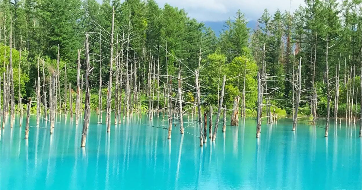
www.kanko-shakotan.jpShirogane Blue Pond (Shirogane Aoi Ike) [Hokkaido, Biei Town]: Cobalt-Blue Water Surface -- 220-Car Parking Lot, 500 Yen (~$3.50 USD) / Fewer Crowds in Early Morning
Officially Shirogane Blue Pond (Shirogane Aoi Ike), located in Shirogane, Biei-cho, Kamikawa District, Hokkaido, Japan. The draw is the water surface that shifts between cobalt blue and milky azure, framed by standing dead trees in quiet composition. It's a well-known pond, but what sets it apart from typical lakeside scenery is that the color itself becomes the subject. The parking lot holds about 220 standard vehicles at 500 yen (~$3.50 USD) per car.
Peak season stretches from fresh green through early autumn, with the blue reading most clearly on bright days. Two timing strategies work here: for fewer crowds, arrive early morning; for the richest blue saturation, visit when the sun is high. Morning favors reflections and solitude, while afternoon rewards color intensity. To beat the main wave, aim for arrival between 7:00 and 8:00 AM, before the late-morning rush hits around 10:30.
Access is easiest by car, fitting naturally into a Biei or Shirogane Onsen (hot spring bath) area circuit. Public transit can get you close, but schedules and connections are limiting. The spot suits Biei driving tours, photography trips, and anyone looking to go one step beyond Hokkaido's standard highlights. For photos, framing the dead trees as foreground against the blue tightens the composition more effectively than sweeping wide shots. Stick to the boardwalk and viewing paths -- blocking the designated route for others is the main etiquette point here.
白金青い池|一般社団法人 美瑛町観光協会
INDEX 四季折々の青い池 アクセス情報 駐車場について ライトアッ�
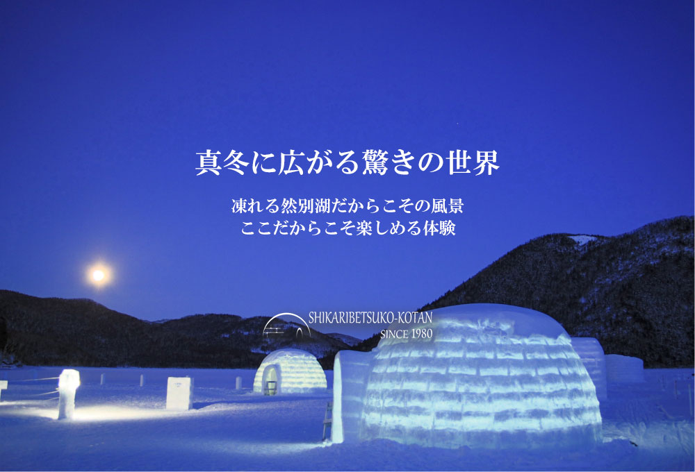
www.biei-hokkaido.jpLake Shikaribetsu (Shikaribetsu-ko) [Hokkaido, Shikaoi Town]: Crystal Clarity in Spring Through Autumn, "Ice Village" on the Frozen Lake in Winter (Late January to Mid-March) -- Two Faces of One Place
Officially Lake Shikaribetsu (Shikaribetsu-ko), located in Shikaoi-cho, Kato District, Hokkaido, Japan. The draw is a place that delivers completely different landscapes by season: spring through autumn brings a quiet, mountain-cradled lake with exceptional clarity, while winter transforms the frozen surface into the "Shikaribetsu-ko Kotan" -- an ice village that feels like a different world entirely. Many lakes in Japan offer scenic beauty, but the dual character of serene waterscape and frozen wonderland in one location is what makes this special. The ice village runs approximately late January through mid-March, with a 500 yen (~$3.50 USD) cooperation fee for entry.
For the lake's pure beauty, peak season is spring through autumn. For the full experience including the winter event, the cold months are the draw. In warmer seasons, calm mornings with light wind produce the best reflections. During the winter Kotan, the choice is between daytime visits for easier conditions and evening visits when lighting effects begin to appear on the ice structures. To avoid peak crowds, shift away from weekend centers during the winter event -- weekdays or early in the event period tend to feel calmer.
Access is most convenient by car, though buses from the Obihiro area and seasonal shuttles may also be available. This spot suits travelers who enjoy revisiting a single place across seasons, those combining with onsen (hot spring bath) stays, and adults seeking quiet nature. For photos, look beyond wide lakeside compositions -- catching the mountain reflections on the water surface brings out what makes Shikaribetsu distinctive. In winter, follow event pathways and ice rules; including the soft glow of artificial light against the frozen landscape shifts the mood in compelling ways.
しかりべつ湖コタン【公式】 | 氷上露天風呂やアイスバーで唯一無二の体験を!
しかりべつ湖コタンは真冬の凍った然別湖に現れる幻の村(コタン)です。氷上露天風呂やアイスバー・アイスロッジでの宿泊体験など、ここでしかできない体験と圧倒的な自然&絶景がそこにはあります。暖かくしてお越しください。
kotan.jpTsutanuma (Tsuta Marsh) [Aomori Prefecture, Towada City]: Autumn Reflections on Still Water -- Calm, Pre-Dawn Mornings Are Everything / Peak Color Around Mid to Late October
Officially Tsutanuma (Tsuta Marsh), located in Towada City, Aomori Prefecture, within Towada-Hachimantai National Park, Japan. The draw is the autumn reflection on the water surface. Plenty of lakes and marshes are known for fall color, but Tsutanuma is special because when soft morning light meets windless air, the trees' colors sink into the water with an almost painted density. Peak foliage centers on mid to late October.
The best season is obviously autumn, and the optimal time is essentially early dawn and nothing else. Visiting around sunrise means factoring in wait time -- this is less "going to see scenery" and more "waiting for conditions to arrive." Wind breaks the spell here more than anything; the stillness of the water surface determines the quality of any photograph far more than the sky's color. To avoid crowds, dodging peak autumn weekends is standard advice, but Tsutanuma concentrates visitors heavily, so planning around the reservation system and thinking of it as a managed-access spot is more realistic than hoping for empty trails.
Access is primarily by car. During peak foliage, a reservation system may apply for the observation deck and parking. The spot suits autumn photography trips, early-rising nature enthusiasts, and loop itineraries combining Oirase Gorge and Lake Towada. For photos, rather than only wide-angle sweeps, cropping into dense clusters of red and orange produces a more refined result. During crowded early mornings, keeping the viewing path clear for others affects the experience just as much as the scenery itself.
十和田市
www.city.towada.lg.jpRyusendo Cave [Iwate Prefecture, Iwaizumi Town]: Total Length 4,088 m with 700 m Open to Visitors and 3 Underground Lakes -- Cool Even in Summer / Watch Your Step
Officially Ryusendo Cave, located in Iwaizumi-cho, Shimohei District, Iwate Prefecture, Japan. The draw is walking 700 meters of a 4,088-meter cave system while viewing three underground lakes of striking clarity. Unlike mountain or ocean scenery, this is a subterranean landscape -- deep blue water emerging from darkness in a space where light barely reaches. The cave combines raw geological power with a well-organized public route, balancing a sense of remote mystery with genuine accessibility.
Peak season is year-round, but the cave truly shines as a summer escape. The interior stays cool, and the hotter it is outside, the stronger the contrast feels walking in. Timing is flexible since natural light plays no role -- no need to chase golden hour -- which makes it easy to slot into broader itineraries. To avoid crowds, weekdays or early mornings beat holiday middays.
Access works well by car and fits into Sanriku coastal driving routes. The cave suits summer cooling-off trips, family outings, and nature lovers who'd rather skip long hikes. For photography, the dark interior invites camera shake, so bracing against railings or walls improves your hit rate. The floor is wet in spots with stairs throughout, so keeping some attention on your footing -- rather than only on the views -- is genuinely important here.
龍泉洞と龍泉新洞科学館 | 観光スポット | いわての旅
岩手県は八幡平のスキー、奥入瀬渓流でのトレッキング、三陸海岸でのサーフィンや海水浴、そして豊かな自然の中でのキャンプなど多彩なアウトドアアクティビティが楽しめます。
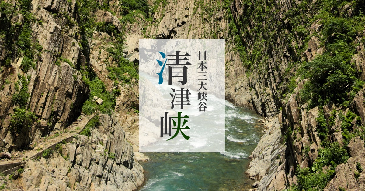
iwatetabi.jpKiyotsu Gorge Tunnel (Kiyotsukyo Keikoku Tunnel) [Niigata Prefecture, Tokamachi City]: Columnar Jointing Viewed Through an Art-Infused Tunnel / 1.5 km Round Trip, 60-90 Min Visit
Officially Kiyotsu Gorge Tunnel (Kiyotsukyo Keikoku Tunnel), located in Tokamachi City, Niigata Prefecture, Japan. The draw is the series of viewing stations carved into the tunnel walls that frame the columnar-jointed gorge, culminating in the water-mirror installation at the far end. The artificial tunnel creates a curated way of experiencing natural grandeur, making this feel more like walking through an art piece than a typical gorge hike. Admission is approximately 1,200 yen (~$8 USD) in peak season and 1,000 yen (~$7 USD) in off-season, though this varies by period and operations. The round trip is about 1.5 km, so budget 60 to 90 minutes including viewing and photography.
The tunnel works across seasons -- fresh green, autumn color, and snow each bring a different mood. Timing is less about chasing light and more about dodging crowd waves. Avoiding weekend late mornings helps; on days with reservation-based entry, booking an early slot pays off.
Access is convenient by car and integrates well with Echigo-Yuzawa or Tokamachi area circuits. Public transit is possible but schedules and connections require attention. The spot suits art-leaning scenery lovers, travelers who need a rain-proof itinerary option, and couples or friend groups. Beyond the famous end-point mirror, photographing the contrast between tunnel walls and the gorge along the way keeps the experience from feeling one-note. The floor gets slippery, and at popular pause points, sharing space graciously is the key to a smooth visit.
日本三大峡谷 清津峡<公式>|新潟県十日町市
新潟県十日町市の日本三大渓谷「清津峡」。雄大な柱状節理の岩肌とエメラルドグリーンの清流が、訪れる人々に深い感動を与えます。渓谷美を間近で堪能できる「清津峡峡谷トンネル」も是非ご利用下さい。
nakasato-kiyotsu.comAkiyamago (Akiyama Village) [Niigata Prefecture, Tsunan Town / Nagano Prefecture, Sakae Village]: Japan's Original Landscape -- Autumn Color Mid-October to Early November / Mountain Road Driving Requires Care
Officially Akiyamago (Akiyama Village), a cluster of settlements along the upper Nakatsu River straddling Tsunan Town (Niigata Prefecture) and Sakae Village (Nagano Prefecture), Japan. The draw is that no single attraction dominates -- instead, mountain hamlets, gorges, and the quiet bearing of the settlements flow together so that the entire area becomes the scenery. Unlike destinations where you drive to one viewpoint, here the journey itself carries a sense of entering a hidden world. Peak autumn color runs mid-October through early November.
Autumn foliage is the prime season, but for those who value quiet over spectacle, the fresh green of early summer also fits beautifully. Morning to mid-morning is ideal, when soft light filters into the valley. Afternoons carry their own mood, but factoring in mountain road driving, keeping the trip centered around daylight hours makes practical sense. Shifting away from peak autumn weekends to a weekday drive preserves the sense of open space that defines Akiyamago.
Access is essentially car-only; public transit involves complex connections. The spot suits adult driving getaways paired with onsen (hot spring bath) stays, unhurried photography without time pressure, and anyone drawn to the feeling of genuine seclusion. Rather than seeking out designated viewpoints, picking up the layered compositions of hamlets against mountain backdrops along the roadside captures the real character of this place. On the safety front, the very scenery that draws your eye makes it easy to lose focus on narrow roads and oncoming traffic -- choosing where to pull over thoughtfully is a prerequisite for enjoying the views.
Metropolitan Area Outer Underground Discharge Channel [Saitama Prefecture, Kasukabe City]: 59 Columns Standing 18 m Tall -- Reservation-Based Tours of the "Underground Temple"
Officially the Metropolitan Area Outer Underground Discharge Channel (Shutoken Gaikaku Hosuiro), located in Kasukabe City, Saitama Prefecture, Japan. The draw is the massive underground space of the pressure-regulating water tank, where 59 columns roughly 18 meters tall create a cathedral-like atmosphere. This isn't a natural landscape, yet it commands the same awe -- the sense of perspective and sheer mass is overwhelming. Being relatively close to central Tokyo with access via reservation-based tours makes this an unusually accessible encounter with something monumental.
Peak season is year-round, and rain or extreme heat barely affects the experience underground. Timing revolves around tour reservation slots rather than natural light, making it one of the easiest scenic experiences to fit into a schedule. That said, popular tour slots fill quickly. Weekday or early-morning slots tend to be calmer than weekend afternoons.
Access centers on buses from the Minami-Sakurai Station area or by car. The spot suits anyone drawn to non-natural spectacles, architecture and civil engineering enthusiasts, and day-trippers from Tokyo. For photos, including a person in the frame to establish scale communicates the enormity far better than columns alone. The tour involves staircase descents, and staying within the designated route is a basic condition for the visit.
Takeda Castle Ruins (Takeda-jo Seki) [Hyogo Prefecture, Asago City]: Elevation 353 m -- The "Castle in the Clouds" Appears on Autumn/Winter Dawns / Both Hiking Trail and Bus Options Require Planning
Officially Takeda Castle Ruins (Takeda-jo Seki), located atop Mount Kojo at 353 meters elevation in Asago City, Hyogo Prefecture, Japan. The draw is the stone wall ruins themselves -- beautiful in their own right -- combined with the phenomenon of a cloud sea engulfing the valley on the right mornings, transforming the site into a "castle floating in the sky." Castle ruins dot Japan, but here historical stonework and meteorological conditions complete the picture together. Late autumn through early winter mornings carry the highest odds.
Peak season is late autumn to early winter, with dawn to early morning as the target window. Because cloud sea formation depends heavily on weather, it helps to think of "visiting the castle" and "chasing the cloud sea" as two separate plans. Even slightly shifting off peak-season weekend mornings makes a noticeable difference in the experience.
Access starts at JR Takeda Station, from which you can hike up or use bus/taxi from Yamajiro-no-Sato as a base. Private vehicle access is restricted on the final stretch, so even driving trips require advance planning for the last leg. The spot suits early risers, history enthusiasts, and people who view uphill walks as part of the scenery rather than an obstacle. Photography diverges completely depending on whether you shoot from within the ruins (stone walls close-up) or from the Ritsuunkyo viewing area (full panorama with cloud sea). The climb is real, and pre-dawn cold adds to the load -- approaching this as "a mountain castle at dawn" rather than a standard tourist site keeps expectations aligned.
竹田城跡公式ホームページ - 朝来市公式ホームページ
www.city.asago.hyogo.jpRyuchin Falls (Ryuchin no Taki) [Nara Prefecture, Uda City]: Emerald Pool with Mirror-Still Water -- Calm, Early Mornings in the Fresh Green Season Are Prime
Officially Ryuchin Falls (Ryuchin no Taki), located in Uda City, Nara Prefecture, Japan. The draw is a rock-enclosed pool at the base of the falls that, under the right light and angle, glows emerald green -- and on windless days, produces mirror-like stillness on the surface. This isn't a thundering waterfall that impresses with power. Instead, it pulls you in with the atmosphere of a small, sacred space. That quality is what separates it from Japan's more famous cascades.
龍鎮の滝(龍鎮渓谷) | 探訪ナビゲーション | うだ探訪ナビ
www.uda-kankou.jpTottori Sand Dunes (Tottori Sakyu) [Tottori Prefecture, Tottori City]: 2.4 km North-South, 16 km East-West -- Seek the Edges and Early Mornings to Avoid Crowds / Watch for Blowing Sand on Windy Days
Officially Tottori Sand Dunes (Tottori Sakyu), located in Tottori City, Tottori Prefecture, Japan. Spanning approximately 2.4 km north-south and 16 km east-west. The draw is experiencing sand as terrain rather than typical Japanese coastal scenery. Despite being extremely well-known, the sheer scale means pockets of quiet and undiscovered texture remain -- particularly away from the central visitor path. Sticking to the standard route through the middle yields a crowded famous-spot experience, but venturing toward the edges reveals wind ripple patterns and undulations with a completely different character.
Peak season falls in spring and autumn when the air is clearest, with early morning as the prime window. Low-angle light brings out the sand's shadows and contours, and fewer footprints mark the surface at dawn. To reduce crowd exposure, move away from the main entrance area and avoid late morning through early afternoon.
Access runs about 20 minutes by bus from JR Tottori Station, or roughly 15 minutes by car from Tottori IC. The spot suits families, road trips, and anyone wanting large-scale scenery in a short visit. Including a small human figure in photographs communicates the dunes' vastness effectively. On windy days, blowing sand can irritate eyes and stress camera gear. Staying within designated areas and out of protected zones is essential.
Tsunoshima Bridge (Tsunoshima Ohashi) [Yamaguchi Prefecture, Shimonoseki City]: 1,780 m Long -- JR Kottoi Station to Bus ~23 Min / Morning Light with Front Sun Brings Out the Sea Color
Officially Tsunoshima Bridge (Tsunoshima Ohashi), located in Shimonoseki City, Yamaguchi Prefecture, Japan. Total length: 1,780 meters. The draw is the exhilarating sight of a bridge stretching straight across cobalt-blue water. Bridges over the sea exist throughout Japan, but here the piers are barely visible, creating the illusion that the bridge glides across the surface. Both crossing the bridge and viewing it from a distance deliver distinct pleasures.
Peak season is spring through summer and into early autumn when the sea color brightens. Morning is the strongest time window -- front lighting brings out the contrast between the sea's blue and the bridge's white. Evening carries its own atmosphere, but for the defining shot, morning wins. Arriving at the mainland-side viewpoints before the late-morning tourist traffic picks up gives you the best conditions.
Access is easiest by car. For public transit, buses from JR Kottoi Station take about 23 minutes. The spot suits scenic drives, couples' trips, and anyone who wants the journey itself to be part of the pleasure. For photos, an angled composition using the coastline and elevation changes creates more dimension than a straight-on bridge shot. Parking on the bridge or nearby roadsides detracts from the scenery; choosing viewing and parking spots thoughtfully is the real access challenge here.
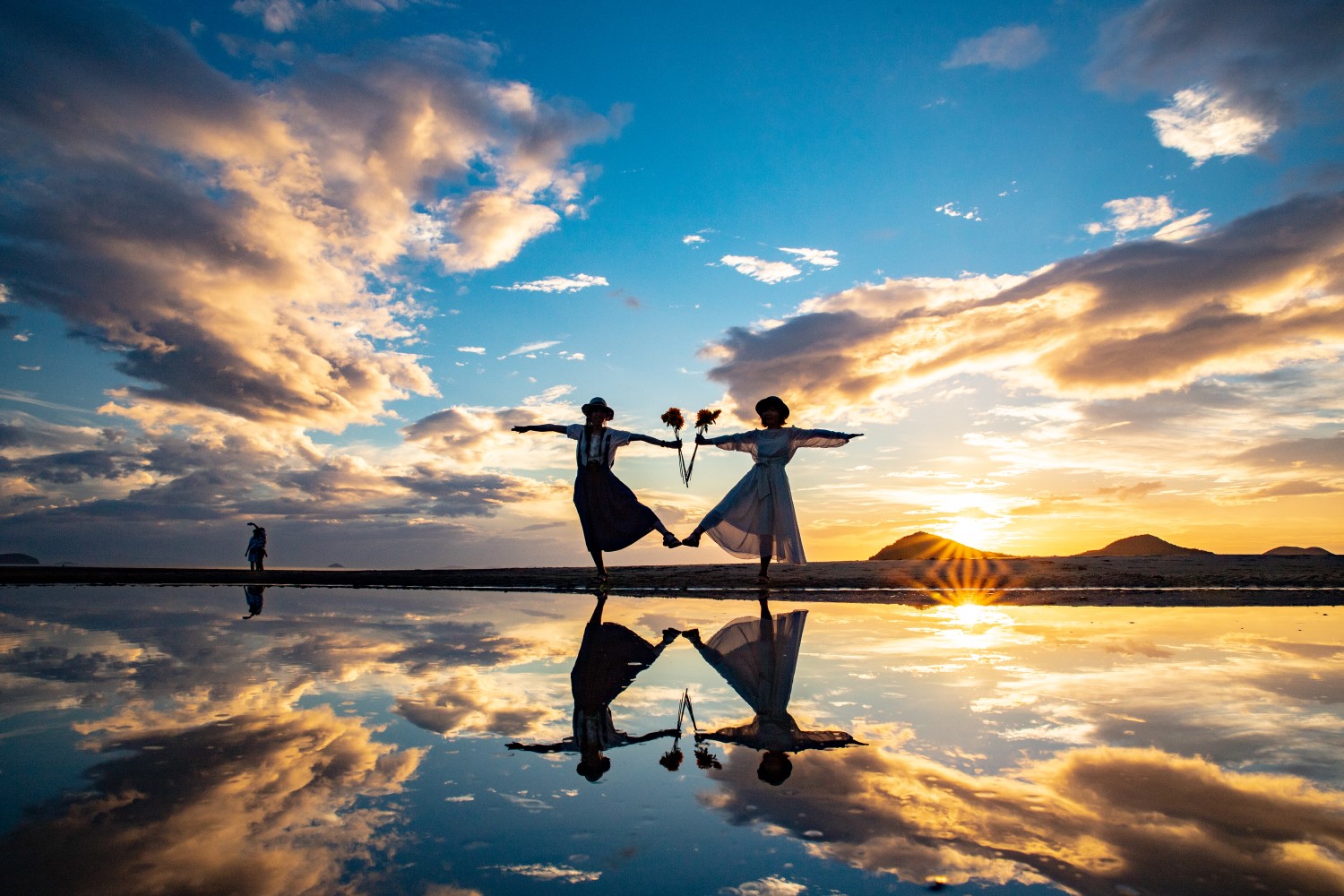
Chichibugahama Beach [Kagawa Prefecture, Mitoyo City]: The Mirror Tide -- Target ~3 Hours After High Tide as Flats Emerge + Zero Wind / Chase the Sunset Color
Officially Chichibugahama Beach, located in Nio-cho, Mitoyo City, Kagawa Prefecture, Japan. The draw is the reflection effect: when conditions align, shallow tidal pools mirror the sky and human silhouettes, producing photographs reminiscent of Bolivia's Uyuni Salt Flat. Coastal sunsets are common across Japan, but here the ground itself becomes a mirror depending on the tide -- and that's the fundamental difference. The sweet spot is approximately 3 hours after high tide, as tidal flats emerge.
💡 Tip
At Chichibugahama, a day with the right tide level and calm wind will often produce better results than one with a spectacular sunset. Even under slightly overcast skies, a still water surface delivers strong photographs.
父母ヶ浜
香川・父母ヶ浜|日本のウユニ塩湖と話題の絶景スポット。干潮×夕日の見頃カレンダーやアクセス情報に加え、周辺の宿泊・ホテル情報も掲載。
www.mitoyo-kanko.comInazumi Underwater Stalactite Cave (Inazumi Suichu Shonyudo) [Oita Prefecture, Bungo-Ono City]: Average 15-16 C Inside -- Perfect Summer Escape / Wear Shoes You Don't Mind Getting Wet
Officially Inazumi Underwater Stalactite Cave (Inazumi Suichu Shonyudo), located in Bungo-Ono City, Oita Prefecture, Japan. The draw is the crystalline underground waterscape unique to a submerged stalactite cave, combined with the mystique of enclosed formations. Compared to typical cave tourism, the presence of water is far more prominent here -- the sound, humidity, and cool air imprint on memory as much as the visuals. The cave interior averages 15-16 degrees Celsius (59-61 F), making it an outstanding summer refuge.
Peak season is year-round, but the value registers most powerfully when the outside temperature is high. Walking in from 30 C (86 F) heat makes the temperature gap unmistakable. Timing-wise, slotting this into a midday break when heat peaks maximizes the contrast. Avoiding midsummer holiday centers and weekday visits tend to be more comfortable.
Access works well by car and fits into Kyushu driving itineraries as a natural detour. The spot suits midsummer travelers, families, cave scenery enthusiasts, and anyone wanting a rain-proof activity. For photos, focus on the water's clarity rather than fighting the darkness -- composing in areas with less extreme light contrast produces the most atmospheric results. The floor gets wet, so prioritize comfortable, grippy shoes over anything you'd want to keep clean.
Nabekanmuriyama Observatory [Nagasaki Prefecture, Nagasaki City]: Elevation 169 m -- A Quieter Alternative to Inasayama for Night Views / Bring a Layer for the Evening Breeze
Officially Nabekanmuriyama Park (Nabekanmuriyama Observatory), located in Nagasaki City, Nagasaki Prefecture, Japan. Elevation: 169 meters. The draw is Nagasaki's city lights curving around the harbor, viewed from a spot that's typically much calmer than the famous Inasayama Observatory. Night view destinations exist everywhere, but the way Nagasaki's terrain wraps light around its bay creates a three-dimensional glow that this observatory captures at just the right distance.
Peak season is whenever the air is clear, though night views work year-round. The real timing insight is to arrive not just after dark, but during the transition from twilight to full darkness. Watching the harbor and hillside lights gradually intensify is part of the beauty. The quieter advantage of Nabekanmuriyama is most pronounced on weekend evenings, precisely when crowds flock to Inasayama instead.
Access is convenient by car, with a walking route of about 10 minutes above Glover Garden also available. The spot suits nighttime dates, solo travelers seeking a quiet perch above the city, and anyone looking for a finishing touch to a day exploring Nagasaki. For photos, the standard composition places the harbor at center, but widening the frame to include the hillside residential lights adds Nagasaki's distinctive character. Evening wind flows freely up here, so factoring in the return walk and temperature drop makes the experience more comfortable -- think of it as visiting an exposed hilltop at night, not just a viewing platform.

鍋冠山公園 眺めを楽しむ公園
鍋冠山公園 眺めを楽しむ公園
www.city.nagasaki.lg.jpPicking by Season -- Scenic Spots That Deliver in Spring, Summer, Autumn, and Winter
The same spot can look completely different depending on when you visit. When building a trip, working backward from "which places are most likely to reward me this season" tends to produce better results than starting with a wish list.
Spring (February - May): Snow Remnants, Fresh Green, and Emerging Sea Color
The spring highlight is Tsutanuma. Most people associate it with autumn foliage, but the transition from lingering snow to fresh green brings a quieter period when visitor intensity drops and the marsh's stillness takes center stage. Water-surface spots respond to calm mornings, so early hours are the match. The colors lack autumn's drama, but the combination of pale green and still-cold air produces a subtly sophisticated landscape.
For ocean scenery, Cape Kamui strengthens from spring into early summer. Shakotan Blue reads as a more refined transparency when the air still carries a dry edge, rather than in the full humidity of midsummer. The walking trail to the tip covers about 20 minutes one way (40 minutes round trip), and front-lit conditions from mid-morning suit the blue-dominant scenery. The cliffs' white rock against the sea color builds contrast effectively in this light.
For fresh green paired with water, Ryuchin Falls is a reliable spring choice. The surrounding trees soften into gentle green, preventing the emerald pool from looking too heavy. This is a place of shade and water-mirror mystique rather than grand cascades, so moderate light -- morning or gently angled afternoon -- suits it well. Low wind settles the water surface and pulls the pool's color together.
Summer (June - September): Go for Color Intensity and Cool Retreats
When summer photography is the goal, Shirogane Blue Pond remains a strong pick. Surrounding greenery hits peak density, creating vivid contrast with the blue water. Early mornings bring calm surfaces and thin crowds, with the dead trees reflecting cleanly. For color saturation alone, afternoon light also performs. "Morning for reflections, afternoon for color" is a practical way to split your planning. Parking: about 220 standard vehicles, 500 yen (~$3.50 USD) per car.
As a heat escape, Inazumi Underwater Stalactite Cave is genuinely useful. The interior averages roughly 15-16 C (59-61 F), and entering from summer outdoor temperatures makes the gap dramatic. Rather than going first thing in the morning, slotting it into the midday heat peak maximizes the relief. As a transit point in a broader itinerary, it also reduces cumulative fatigue from sun-exposed scenic spots.
Ryusendo Cave is another strong summer option. The 700-meter public section with its underground lakes goes well beyond a simple cool-down break. The interior sits around 10-11 C (50-52 F), cold enough that staying in short sleeves will leave you genuinely chilled during the tour. Afternoon entry, when outdoor heat is at its worst, tends to heighten the impact. Eyes adjusted to bright sunlight perceive the underground lake colors as even deeper blue.
ℹ️ Note
In summer, rather than battling midday heat at an exposed viewpoint, sequencing your day as "water surfaces in the morning, caves at midday, observatories in the evening" protects both visual satisfaction and physical stamina.
Autumn (September - November): The Season for Foliage and Cloud Seas
The autumn anchor is Tsutanuma. Peak color runs mid to late October, and the intensity of reds and oranges reflected on the water surface is remarkable when conditions align. This is the textbook case where timing determines the scenery: arriving before dawn and waiting for wind to stay low is how the reflection comes together. Getting there before the air starts moving, rather than after daylight is established, is what separates a good visit from a great one.
For an autumn driving experience, Akiyamago delivers consistently. Color peaks mid-October through early November, and because the gorge, mountain slopes, and village rooftops color together as one continuous canvas, the trip becomes "the scenery is good throughout the drive" rather than a single-viewpoint experience. Mornings bring soft valley light, while late afternoon deepens mountain shadows and the sense of seclusion.
For cloud sea chasers, Takeda Castle Ruins is the autumn essential. Late autumn dawns lean toward the "castle in the sky" appearance, especially on clear mornings following radiative cooling. At roughly 353 meters elevation, the castle structure itself is worth seeing, but for the cloud sea, the honest framing is: "this is a place worth an early, cold morning visit." The cloud sea window is brief -- it fills before sunrise and begins dissolving as the sun climbs -- so building the day around pre-dawn arrival is the approach that matches reality.
Winter (December - February): Ice, Crisp Air, and Snow as Scenery
For an experience that exists only in winter, Lake Shikaribetsu stands alone. The "Shikaribetsu-ko Kotan" ice village appears roughly late January through mid-March, with an entire small village materializing on the frozen lake surface. Daytime spreads a white world, and as evening approaches, light playing on ice structures becomes the visual anchor. The cold itself is part of the scenery. For the quiet lake landscape, visit spring through autumn; for the event experience with the deepest sense of unreality, winter is unmatched.
To capture city light through winter air, Nabekanmuriyama Observatory is the pick. At 169 meters, it sits close enough to the city for the lights to feel detailed, and on clear, dry nights the glow neither bleeds nor hazes. The window to target is from just after sunset through full darkness, as Nagasaki's layered terrain transitions from outlines to a luminous surface. Winter air carries the best transparency, making the city's complex topography readable as broad planes of light rather than indistinct shimmer.
For snow as a primary element, water-feature spots like Tsutanuma and Ryuchin Falls take on a distinctive winter hush, but for planning ease, three options stand out for seasonal fit: Lake Shikaribetsu with its event structure, Nabekanmuriyama for its air clarity advantage, and Kiyotsu Gorge Tunnel for the contrast between the engineered space and the snow outside. When choosing by season, the simplest framework is: spring for fresh green, summer for cool retreats, autumn for foliage and cloud seas, winter for snow and transparency.
Photography Tips and Crowd-Avoidance Strategies
Improving your photo results starts with a mindset shift: choose conditions, not just locations. Wind, tide, light, cloud cover, and arrival time can transform the same spot from ordinary to extraordinary. Hidden scenic spots amplify this dynamic -- a 30-minute difference in timing can determine your entire trip's highlight.
For Reflections, Calm Wind Outranks Everything
At mirror-surface spots, wind is the first variable to check. Chichibugahama, Ryuchin Falls' pool, and Tsutanuma all rely on the water surface as the main subject, and stillness beats ideal lighting every time. A good reflection day doesn't just mean "calm water" -- the surface looks frozen solid, and even a light breeze smears the edges.
Target early mornings when wind tends to drop, or at coastal spots, the evening lull period. Even at Chichibugahama when chasing sunset silhouettes, factoring wind forecasts into the plan improves your success rate more than just tracking sunset times. Mountain-side water features like Tsutanuma and Ryuchin Falls also favor the pre-dawn window before the air begins to stir. The difference-maker isn't expensive gear -- it's reading the wind.
Chichibugahama Requires Tide Tables, Not Just a Sunset Forecast
Chichibugahama doesn't work by simply showing up at sunset. The tidal mirror forms most reliably about 3 hours after high tide, as the water recedes and tidal pools emerge on the flats. When this timing coincides with zero wind, the pools capture sky color in full.
The practical approach is to cross-reference tide tables with sunset time. Using sunset alone as your anchor risks arriving to find the water either too receded or the pools not yet formed. Chichibugahama is a "tide spot" before it's a "sunset spot" -- reversing that priority is the most common planning mistake.
Sea and Bridge Colors Shift With Light Direction
Ocean scenery changes character based on where the sun sits. Tsunoshima Bridge, for example, renders its strongest blue-and-white contrast under front-lit morning to midday conditions. The sea stays vivid and the bridge's white doesn't wash out, making it the most forgiving window for first-time visitors.
For dramatic mood, backlighting from a setting sun works differently. Human silhouettes at Chichibugahama, graduated sky tones over the coast, twilight city light from Nabekanmuriyama -- these all benefit from having the light source behind the subject. When aiming for sky drama, days with 20-60% cloud cover produce richer color gradations than clear skies. Night views, conversely, depend on air clarity. At Nabekanmuriyama, lower humidity means less light bleed and crisper topographic detail.
Takeda Castle's Cloud Sea Needs More Than an Early Alarm
Catching the cloud sea at Takeda Castle Ruins requires more than just showing up before dawn. The formula is clear late-autumn or early-winter mornings with radiative cooling and humidity from the previous evening. On the right mornings, cold valley air pools and is lifted by the first sun into visible cloud, completing the scene in a narrow window.
Plan to arrive 30 to 60 minutes before sunrise. Arriving after daylight typically means the cloud layer has already thinned or lifted. Takeda Castle's appeal at 353 meters elevation is less about the height itself and more about treating it as a weather phenomenon you go to witness. Setting expectations this way avoids the disappointment of a blue-sky visit without clouds.
Underground and Tunnel Venues: Footwork and Moisture Matter More Than Darkness
Kiyotsu Gorge Tunnel, Ryusendo Cave, and Inazumi Underwater Stalactite Cave require different preparation from open-air scenic spots. Key questions: Can you use a tripod? Is the route one-way or round-trip? Are there wet sections? Kiyotsu's 1.5 km round trip means photography stops affect the flow for others, and on busy days, choosing where to pause becomes a social skill.
Underground, the real enemy is lens condensation, not darkness. Entering Ryusendo Cave on a hot day can fog your lens for the first few minutes. Rather than rushing to frame a shot, pausing near the entrance to let your equipment acclimate pays off in both comfort and image quality. Floors tend to be wet, so at places like Inazumi Cave, practical footwear beats presentable footwear every time.
Beat Crowds With Positioning, Not Just Timing
The classic timing advice -- weekdays, right at opening, just before closing -- holds strongly at scenic spots, and the payoff is amplified when photography is the goal. At Shirogane Blue Pond, mornings are visibly calmer; at Kiyotsu Gorge Tunnel, crowds build through the mid-visit period. Arrival time alone can determine whether you get the shot you came for.
Spatial strategy matters too. Tottori Sand Dunes are vast enough that shifting toward the edges rather than clustering at the popular central area reveals cleaner compositions with fewer footprints. The same principle applies to night views: rather than heading straight for the most publicized observatory, choosing the alternative vantage point delivers a quieter experience without sacrificing quality. In Nagasaki, picking Nabekanmuriyama over Inasayama is exactly this kind of move -- same city lights, far fewer people.
⚠️ Warning
Photography-focused itineraries benefit from going one level finer than "best season" -- planning down to wind, tide, light direction, and arrival time meaningfully reduces missed opportunities. Scenic quality is half the place, half the conditions.
Access Comparison Table -- Public Transit vs. Driving
When transportation is the sticking point, sorting spots into public-transit-friendly and car-essential categories narrows the field quickly. Scenic destinations draw attention for their views, but actual satisfaction depends heavily on "can I get there without strain?" and "how much walking is involved?" The 15 spots in this guide range from urban-adjacent facilities to mountain-road-only retreats, so checking travel compatibility before scenic preference prevents the most common planning frustrations.
Relatively public-transit-friendly: the Metropolitan Area Outer Underground Discharge Channel, Kiyotsu Gorge Tunnel, Nabekanmuriyama Observatory, Takeda Castle Ruins, and Tottori Sand Dunes. The Discharge Channel fits neatly into a Tokyo day trip, with the guided tour format making on-site movement predictable. Kiyotsu Gorge Tunnel connects via bus from Echigo-Yuzawa, making it a natural addition to a train-based itinerary. Nabekanmuriyama is reachable by Nagasaki city bus plus a short uphill walk -- light for a night view spot. Takeda Castle Ruins use JR Takeda Station as a base, though how you handle the uphill section changes the effort level. Tottori Sand Dunes are about 20 minutes by bus from Tottori Station -- straightforward access for their massive scale.
On the other hand, Tsunoshima Bridge, Cape Kamui, Akiyamago, Chichibugahama, and Tsutanuma lean strongly toward car access. Tsunoshima Bridge rewards driving both for the crossing experience and for hitting multiple viewpoints along the coast. Cape Kamui sits within a Shakotan Peninsula drive where the coastal road is itself part of the attraction. Akiyamago works as a connected series of hamlet-and-gorge views best experienced through a car windshield. Chichibugahama's sunset-chasing nature, with its unpredictable timing, benefits from the flexibility a car provides for waiting and repositioning. Tsutanuma's early-morning orientation makes transit logistics especially tricky, and during autumn foliage, the transportation plan becomes the trip's structural backbone.
Quick-Reference Access Comparison
| Category | Spot | Walking Effort | Parking | Notes |
|---|---|---|---|---|
| Public transit | Metropolitan Area Outer Underground Discharge Channel | Low | Available | Reservation-based tours. Walking within the tour is light, though stairs are involved |
| Public transit | Kiyotsu Gorge Tunnel | Moderate | Available | Bus from Echigo-Yuzawa. The tunnel round-trip adds up to solid walking |
| Public transit | Nabekanmuriyama Observatory | Low-Moderate | Available | Reachable by Nagasaki city bus. Short uphill to the observatory; footing on the return at night deserves attention |
| Public transit | Takeda Castle Ruins | Moderate | Available | JR Takeda Station works as a base, but includes uphill. Bus or taxi helps manage effort |
| Public transit | Tottori Sand Dunes | Moderate | Multiple lots | ~20 min by bus from Tottori Station. Entry is easy; walking on sand itself is the physical factor |
| Car | Tsunoshima Bridge | Low | Multiple points | Viewing spots scattered along the area. Car allows you to shift vantage points easily |
| Car | Cape Kamui | Moderate | Available | Best as part of a Shakotan Peninsula drive. The trail has elevation changes; the round trip feels earned |
| Car | Akiyamago | Low | Available | Village walking is light, but mountain road driving is the real effort component. Narrow roads may stress some drivers |
| Car | Chichibugahama | Low | Paid lots nearby | Walking is minimal. Planning centers on timing arrival to match tidal conditions rather than avoiding crowds |
| Car | Tsutanuma | Low | Available | Early morning logistics need to be solved first. Autumn foliage period changes parking and deck access rules from normal operations |
| Car-leaning supplement | Shirogane Blue Pond | Low | 220 spaces, 500 yen (~$3.50 USD) | On-site walking is easy. Clear parking terms make it a natural add-on for rental car trips |
Using this table, a traveler seeking "public transit, low walking effort, predictable on-site flow" quickly narrows to the Metropolitan Area Outer Underground Discharge Channel, Nabekanmuriyama Observatory, and Tottori Sand Dunes. "Car-based with scenery connecting the drive" points to Tsunoshima Bridge, Cape Kamui, and Akiyamago. "Photography timing is critical and I need flexibility to wait and reposition" makes Chichibugahama and Tsutanuma the clear car-advantage picks.
Walking effort deserves honest assessment beyond first impressions. Takeda Castle Ruins live up to "mountain castle" -- the climb is real. Cape Kamui's trail is less a beachside stroll and more an undulating cape walk. Nabekanmuriyama's short uphill keeps things light, and the Discharge Channel's tour format means low physical demand. In Akiyamago, the physical load centers on the drive itself rather than on-foot exploration.
For parking predictability, Shirogane Blue Pond's 220-space lot at 500 yen (~$3.50 USD) is among the easiest to plan around. Tottori Sand Dunes offer multiple lots and work for both transit and car visitors. Tsunoshima Bridge's surroundings let you pick parking spots corresponding to your preferred viewing angle. Chichibugahama's paid lots require arrival timing that accounts for the overlap between optimal scenery conditions and peak crowds.
ℹ️ Note
If narrowing to three spots by access, evaluate along three axes: ease of public transit, on-site walking effort, and parking predictability. When scenic appeal is roughly equal, the destination that creates less logistical friction will consistently produce higher satisfaction.
Safety, Etiquette, and Conservation at Hidden Scenic Spots in Japan
Hidden scenic spots may feel free and open precisely because fewer people visit, but in reality, the line between walkable ground and restricted ground is often sharply drawn. Cliff edges, protected dune areas, and cape trails all have boundaries where stepping off the path jeopardizes both the landscape and personal safety. Cape Kamui's coastal trail is more wind-exposed than it appears, and where you stop matters for safety. Tottori Sand Dunes, despite their open appearance, contain areas requiring conservation awareness. A single step taken for a photo can damage vegetation or cause disorientation on the return. Staying on marked trails and out of restricted zones is the most effective single rule.
Don't Assume Access Is Guaranteed
The more "hidden" a spot, the less certain it is that you'll actually be able to see it on any given day. Cape Kamui's trail gate operations shift with season and weather. The Metropolitan Area Outer Underground Discharge Channel operates on a reservation system with conditions that may vary. Natural sites close for wind, waves, rockfall, or snow. Facilities shut down for maintenance or operational reasons. For these destinations, a recent official announcement is worth more than a months-old travel blog post. The higher a facility's update frequency, the faster old information becomes unreliable.
In Bad Weather, Cut the "Maybe I Can Still Make It" Thinking
Coastlines, cliffs, suspension bridges, and mountain roads are all more fragile under bad conditions than fair-weather impressions suggest. Coastal routes add strong wind and high waves, mountain routes add fog, snow, and black ice. Takeda Castle Ruins, with their early-morning schedule, add darkness and cold to the equation. Akiyamago's mountain roads are susceptible to post-rain rockfall and closures. On days involving severe weather or disaster warnings, the speed of your decision to turn back protects the quality of your overall trip. If evacuation advisories are active, waves are washing over the trail, wind is pushing you off balance, or the road surface is iced white -- these are no longer sightseeing conditions.
National and Quasi-National Parks Require a "Leave It Quiet" Mindset
Tsutanuma sits within Towada-Hachimantai National Park; Ryuchin Falls lies within Muroo-Akame-Aoyama Quasi-National Park. Visitor conduct standards in these areas run stricter than at general tourist spots. No collecting plants or animals, no taking rocks or driftwood, carry out all trash, keep volume down and observe quietly. Drone use follows the same principle -- "no one's around so I can fly" doesn't hold, as natural park law and facility regulations apply. Many hidden scenic spots derive their appeal from the very quiet that surrounds them, so not importing noise is itself a form of respect.
Caves and Tunnels Need More Than Street Clothes
Underground scenic venues expose preparation gaps more than open-air ones. Ryusendo Cave's public section carries persistent moisture and cool temperatures, so even summer visitors in short sleeves will feel genuine chill partway through. Kiyotsu Gorge Tunnel's floor gets wet, and focusing on photography makes it easy to forget about footing. At these spots, slip-resistant shoes are the top priority, with rain gear useful in wet conditions. Some darker sections might benefit from a headlamp, but check facility rules on what's permitted. Even short visits can quietly drain energy when low temperatures and humidity work in combination.
💡 Tip
At capes, sand dunes, caves, and gorge tunnels, "what you can see" is not the same as "where it's safe to go." The maintained pathways provide more than enough scenery. The more hidden the spot, the more your trip's success depends on caution.
The information in this guide cross-references multiple sources current as of 2024-2026. That said, operating hours, fees, transit options, reservation requirements, and access restrictions are among the fastest-changing data points in travel. Trail openings, tour operations, foliage-season special rules, and winter closures are particularly fluid -- conditions at the same spot can differ substantially between visits. Keeping this in mind is what turns a trip to see scenery into a trip you actually enjoy.
Who Should Go Where -- Picking Spots for Solo Travelers, Couples, and Families
Trip satisfaction depends not just on scenic power but on who you're traveling with and how you move. Here's a breakdown matching spot characteristics to travel style -- solo seekers of quiet, couples wanting a mood-setting drive, and families needing manageable logistics.
Best for Solo Travel
Traveling alone, you want scenery that rewards standing still and absorbing, not just snapping and moving on. The top pick is Tsutanuma. During autumn, it's known for photography, but the true appeal is the predawn stillness -- watching the water surface slowly accept color as the sky brightens is an experience that fits solitude perfectly. This is a place for receiving rather than consuming.
Akiyamago also suits solo wandering. Rather than one hero viewpoint, it accumulates impressions through modest villages, riverside scenery, and mountain-hamlet atmosphere gathered at an unhurried pace. Those who resist overscheduling get the most from it. Ryuchin Falls takes this further into the contemplative. In fresh green season, the combination of water sound and dense greenery recalibrates your mental state. Sitting by the emerald pool with nothing particular to do is exactly the point.
Transport and time estimates: Tsutanuma is car-oriented (early morning viewing, 1-2 hours); Akiyamago is essentially car-only (half-day circuit); Ryuchin Falls is most practical by car (1-1.5 hours including the walk in and back).
Best for Couples
For couples, scenic quality plus a journey that builds energy together is the formula. Cape Kamui is the archetype -- the open feeling of sea and wind shared on the cliff walk generates natural conversation. The trail's elevation changes make it an experience rather than a quick photo stop. It's the kind of scenery that draws words out of you.
For a driving date, Tsunoshima Bridge delivers. The 1,780-meter crossing itself creates a moment of anticipation as the water color appears, and shifting viewpoints around the bridge area provides variety without heavy walking. To extend into evening, Nabekanmuriyama pairs well. The 169-meter observatory's view of Nagasaki at night is more intimate than high-rise decks in big cities -- the harbor town's lights feel close and three-dimensional. The evening breeze rounds out the atmosphere.
Transport and time estimates: Cape Kamui is car-oriented (trail round trip ~40 min); Tsunoshima Bridge is ideal by car (1-2 hours including viewpoints); Nabekanmuriyama is car or taxi-oriented (night viewing 30 min to 1 hour).
Best for Families
Family trips prioritize low walking effort, clear logistics, and whether children will remember it. Shirogane Blue Pond is the standout. With 220 parking spaces at 500 yen (~$3.50 USD) per car, a well-maintained path, and no steep climbs, it delivers scenery to kids without demanding much. "Going to see the blue pond" is a concept a child grasps immediately, and even short visits satisfy.
For an educational angle, the Metropolitan Area Outer Underground Discharge Channel impresses children and adults alike. The scale of 59 columns at 18 meters tall sticks in memory, and the infrastructure context -- why does this massive facility exist? -- opens up conversation. Tottori Sand Dunes suit families who want physical engagement. At 2.4 km by 16 km, the landscape rewards running, climbing, and exploring, making the terrain itself the activity. On-site experiences like camel rides may be available, but check current operations through the facility directly.
Transport and time estimates: Shirogane Blue Pond is a quick car stop (30 min to 1 hour); the Metropolitan Area Outer Underground Discharge Channel works via both transit and car (tour 1-2 hours); Tottori Sand Dunes are accessible by car or bus (1.5-3 hours with activities).
Best for Photography Enthusiasts
When photography is the primary objective, choose places where the image completes only when conditions converge. Chichibugahama leads this category -- when the tide ebbs, wind vanishes, and the sky carries color, the reflective composition assembles itself with remarkable flexibility for framing.
Kiyotsu Gorge Tunnel draws photographers to the mirror installation at the far end. The walk feels short but the 1.5 km round trip plus waiting and shooting time fills 60-90 minutes comfortably. Takeda Castle Ruins reward those who accept the difficulty of reading conditions in exchange for high payoff when it works. The combination of castle ruins and cloud sea at 353 meters is less a scenic visit and more a "phenomena-waiting station." This one is for early risers who treat weather forecasting as part of the creative process.
Transport and time estimates: Chichibugahama is car-convenient (sunset targeting, 1-2 hours); Kiyotsu Gorge Tunnel leans car-oriented (viewing and shooting 60-90 min); Takeda Castle Ruins work by car or train (commit a half-day morning block).
Best for Onsen, Summer Escapes, and Seasonal Experiences
For heat relief or immersive seasonal encounters, caves and highland lakes are the candidates. Inazumi Underwater Stalactite Cave at 15-16 C (59-61 F) makes the temperature gap visceral in summer. Ryusendo Cave's cool interior across its 700-meter public route offers a similar effect. Both turn "escaping the heat" into a scenic experience rather than just a break.
On the opposite end, winter's special character belongs to Lake Shikaribetsu. The lake's quiet beauty spans three seasons, but winter transforms it entirely. The Shikaribetsu-ko Kotan ice village (roughly late January through mid-March) carries a sense of unreality stronger than typical snow scenery, where the cold itself becomes the experience. Pairing it with an onsen stay is a natural fit.
Transport and time estimates: Inazumi Cave and Ryusendo Cave are both car-friendly (30-60 min visits); Lake Shikaribetsu is reachable by car or bus (lakeside 1-2 hours; half-day with the winter event for an unhurried pace).
ℹ️ Note
A quick sorting framework: for quiet contemplation, try Tsutanuma, Akiyamago, or Ryuchin Falls. For couples' atmosphere, consider Cape Kamui, Tsunoshima Bridge, or Nabekanmuriyama. For family-friendly logistics, look at Shirogane Blue Pond, the Metropolitan Area Outer Underground Discharge Channel, or Tottori Sand Dunes. When scenic appeal is roughly equal between options, choosing the spot that fits your travel companions tends to produce more consistent satisfaction.
Your Next Steps Toward Booking the Trip
Moving from reading to an actual itinerary works best with a simple sequence. Start by narrowing candidates to three spots using just two filters: season and transportation mode. Adding more candidates than that usually means neither timing nor logistics align well, reducing your chances of hitting the scenery at its best.
For example, if autumn mornings are the focus, the split is clear: cloud sea chasing at Takeda Castle Ruins, foliage reflections at Tsutanuma, or a quiet mountain-village drive through Akiyamago. Summer driving pairs naturally with Cape Kamui and Tsunoshima Bridge, with Inazumi Cave or Ryusendo Cave slotting in as a cooling stop. Public-transit travelers gain stability by keeping the logistically simple options -- the reservation-based Metropolitan Area Outer Underground Discharge Channel, bus-accessible Tottori Sand Dunes, or Tsunoshima Bridge via JR Kottoi Station.
Once you have three candidates, the next step is checking each facility's or municipality's official site to confirm it's accessible on your planned dates. This goes beyond operating hours. Takeda Castle Ruins adjust access times and routes seasonally. Kiyotsu Gorge Tunnel shifts to reservation-based entry on busy days. Tsutanuma introduces deck and parking reservations during peak foliage. Cape Kamui's trail gate moves with season and weather. For nature-based trips, confirming "can I enter, can I walk, can I see it" before confirming "do I want to go" is the practical priority.
To sharpen scenic quality further, check condition forecasts the day before. Chichibugahama trips revolve around tide tables. Takeda Castle Ruins require reading cloud-sea probability and overnight temperature differentials. Coastal spots like Cape Kamui and Tsunoshima Bridge shift not just with sunshine but with wind strength. Mirror-water spots like Shirogane Blue Pond and Tsutanuma transform based on whether you can identify the low-wind window. Scenery is never determined by the destination name alone -- tide, wind, cooling, and residual cloud cover collectively decide what the place shows you on any given day.
At the itinerary-building stage, stop thinking spot-by-spot and instead anchor the schedule around sunrise and sunset times. Chichibugahama orients toward evening, Takeda Castle Ruins and Tsutanuma demand early morning, Nabekanmuriyama belongs after dark, and Shirogane Blue Pond splits between dawn stillness and afternoon color. Each scenic spot has an optimal time slot -- fix that slot first, then arrange accommodations, car rentals, and train or bus connections around it. This approach assembles trips far more effectively than lining up attractions in geographic order.
Building a 1-Night, 2-Day Trip
With one overnight, keep the main scenic moments to two at most. For instance, arriving at Tsunoshima Bridge on the first afternoon, taking in the coastal scenery, staying overnight nearby, and adding a second ocean-view spot the next morning makes a clean structure. Photography-focused travelers can use day one for transit and scouting, then place the real shoot at Takeda Castle Ruins or Tsutanuma at dawn on day two. Kiyotsu Gorge Tunnel, where 60-90 minutes of visit time adds up, works better as a dedicated block than as something squeezed into a travel day.
Why 2 Nights, 3 Days Makes Everything Easier
A third day lets you combine dawn-oriented and sunset-oriented scenic spots in the same trip. In Hokkaido, placing Shirogane Blue Pond in the morning and dedicating a separate day to Cape Kamui or Lake Shikaribetsu absorbs the driving distance without wasting prime scenic hours. In Tohoku, Ryusendo Cave fits a midday cooling slot while Tsutanuma claims its own pre-dawn morning. In Kyushu, a midday Inazumi Cave visit for temperature contrast followed by Nabekanmuriyama's night view distributes "cool spaces" and "light spaces" across time slots naturally.
💡 Tip
The most practical planning sequence: narrow to 3 spots -> check official sites for access, restrictions, and reservations -> verify tide/cloud/wind forecasts the day before -> anchor sunrise and sunset, then fit lodging and transport around them.
Following this order shifts your plan from a list of places you'd like to visit to a strategy for maximizing the odds of actually seeing the scenery at its finest. Scenic travel isn't decided by spot selection alone -- it's the placement of time that determines satisfaction.
Related Features and Deeper Guides
This page serves as a broad overview of hidden scenic spots across Japan. Once your travel priorities start to crystallize, diving into theme-specific guides becomes the most efficient next step. If ocean color is your top priority, a "choosing by the bluest water" approach works. If autumn stillness is the draw, narrowing through "off-the-beaten-path foliage spots" is the better filter. If the journey itself is the destination, guides organized around "Shikoku local trains + scenery" or "Kyushu scenic drives" reveal routing logic that individual spot profiles can't provide.
If spots like Tsunoshima Bridge, Cape Kamui, or Shirogane Blue Pond caught your attention -- places where color drives the trip's lasting memory -- a sea-and-lake feature comparing blue intensity, transparency, and water type helps refine your decision. If Tsutanuma, Akiyamago, or Ryuchin Falls appealed for their uncrowded autumn atmosphere, a foliage guide built for those skipping the marquee names provides better seasonal timing and selection contrast.
Travelers drawn to Chichibugahama or Takeda Castle Ruins tend to gravitate toward trips structured around catching a narrow conditions window. Meanwhile, those attracted to the Metropolitan Area Outer Underground Discharge Channel, Ryusendo Cave, or Inazumi Cave -- places offering an atmosphere separated from the surface world -- benefit from following experience-type guides rather than regional ones. Whether your priority is photography, quiet walks, or driving pleasure changes which guide to read next.
For anyone considering Shikoku, Chichibugahama alone barely scratches the surface. Connecting local train rides with small coastal views reveals the region's character far more fully. Kyushu-focused travelers can combine Nabekanmuriyama's night views, Inazumi Cave's cool relief, and the terrain's coastal and mountain variety into a route where the driving itself feels rewarding. If island travel appeals, the sense of "disconnected time" offered by islands differs fundamentally from bridge-connected ocean scenery, making a beginner's island guide a natural entry point.
ℹ️ Note
When in doubt, start with one of these four threads: choosing by the bluest water / off-the-beaten-path autumn foliage / Shikoku local train + scenery / Kyushu scenic drives. Reading just one that matches your travel style usually clarifies the next decision.
When reading across multiple guides, organize by what kind of scenic time you want to claim rather than by place recognition. That distinction -- heading for the ocean, chasing a mountain dawn, walking through underground quiet -- sharpens your destination choice and makes the whole planning process noticeably easier.
Related Articles
12 Hidden Autumn Foliage Spots in Japan: Beat the Crowds with Timing and Access Tips
Want to enjoy koyo (autumn foliage) without fighting through packed tourist sites? This guide narrows it down to 12 quieter spots across Kanto and Kansai, starting with a comparison table so you can zero in on the right fit fast.
8 Hidden Scenic Spots in Japan's Tohoku Region: Season, Difficulty, and Access Compared
Planning a trip to remote, stunning landscapes in Tohoku, Japan? Road conditions, ropeway schedules, and seasonal bus routes can dramatically change how difficult each spot is to reach. Mountain roads, aerial tramways, and seasonal services shift frequently, so
8 Stunning Blue Beaches in Japan Ranked by Water Clarity
Most people pick beaches by gut feeling, but separating water clarity from how blue the ocean actually looks changes the game entirely. This guide covers eight standout beaches across Japan, from remote Okinawan islands to accessible mainland shores, for travelers who prioritize crystal-clear water and vivid blue hues.
15 Best Regional Food Destinations in Japan: Local Specialties by Prefecture
When researching what to eat on a trip to Japan, terms like gotouchi gourmet, kyodo ryori, and meibutsu ryori can blur together, making it hard to pick a destination. This guide sorts out those distinctions using official sources such as the Ministry of Agriculture's regional cuisine database, Japan Tourism Agency statistics, and B-1 Grand Prix data, then narrows the field to 15 prefectures for easy trip planning.